
makiki
what makiki means
In 1831, an Austrian botanist named Dr. F. J. F. Meyen hiked through what we now call Makiki Valley. He described it as a thriving place filled with Hawaiian huts, loʻi kalo (taro patches), and gardens of sugarcane and banana. He also noted something remarkable — a basalt quarry along the ridgeline where local Hawaiians were chipping the basalt rock into pieces used for fishing lures.
(Source: Dr. F. J. F. Meyen, “Reise um die Erde,” 1831; summarized by TantalusOahu.com, “History,” https://tantalusoahu.com/about/history/)
That detail helps explain where the name Makiki may have come from. One interpretation of the word refers to a type of stone used as a weight in traditional Hawaiian octopus lures, known as Leho Heʻe. These lures were carefully crafted using a cowry or pearl shell and a basalt stone weight — the makiki — which helped the lure sink and move naturally in the water to attract octopus.

Replica of traditional Hawaiian fishing lure (Leho Heʻe), showing basalt stone. Courtesy of the National Park Service, Haleakala National Park.
Source: nps.gov/hale/learn/historyculture/hawaiian-fishing.htm
This connection between mountain stone and ocean practice shows how Hawaiians lived in full relationship with their environment. The basalt rock found high in the valley was shaped and carried down to the sea — a reminder that everything from mauka to makai was part of one continuous system.
Geography of Makiki

Makiki sits in the heart of Honolulu, nestled between Downtown Honolulu, Puowaina (Punchbowl), and Manoa Valley. The area stretches mauka (toward the mountains) from King Street up toward Round Top Drive and the forested ridges of Pu’u ‘Ohi’a (Mount Tantalus).
It lies between Punahou Street on the east, Pensacola Street on the west, King Street on the south, and extends mauka (toward the mountains) to Makiki Heights and Tantalus Drive. The area sits along the lower slopes of the Koʻolau mountain range, with Makiki Stream once flowing through the valley toward the Ala Wai Canal. Its mix of urban housing, schools, parks, and forested uplands.
Source: City & County of Honolulu, Neighborhood Commission Office. Makiki–Tantalus Neighborhood Board Boundary Description. https://www.honolulu.gov/nco/boards-and-sub-district-boundary-descriptions
Makiki by the Numbers
According to the City & County of Honolulu’s 2022 Department of Planning and Permitting (DPP) report, the Makiki–Tantalus area is home to approximately 33,352 residents.
Population: ≈ 33,352 residents
Median Household Income: $67,192
Average Household Size: 2.03 people
Total Housing Units: 17,515
Racial / Ethnic Composition:
Asian – 49.9 %
White – 18.4 %
Native Hawaiian & Other Pacific Islander – 12.7 %
Black or African American – 1.8 %
American Indian & Alaska Native – 0.1 %
Some Other Races – 0.7 %
Data is sourced from the City & County of Honolulu Department of Planning and Permitting’s FY 2022 Annual Report. Percentages reflect residents who identified with one race in the survey results
Source: City & County of Honolulu, Department of Planning & Permitting. FY 2022 Annual Report, pp. 59–62.https://www.honolulu.gov/dpp/wp-content/uploads/sites/56/2024/07/AnnualReportFY2022.pdf
History of Makiki
Before Makiki became the neighborhood we know today, the area was once covered in native forest and flowing streams that fed loʻi kalo (taro patches). The upper ridges were home to koa, ohi’a, lama, and kukui trees, while the valley below supported lo’i patches that sustained the families who lived here.
When Western ships began arriving in the late 1700s, Honolulu Harbor became a center of trade. Its proximity made Makiki an ideal area for logging and agriculture. The forests on the ridges behind Makiki were quickly cleared — first for fuel and timber, and later to make room for cattle ranching, sugar, and coffee.
By the mid-1800s, early forestry records described the slopes of Makiki and Tantalus as nearly bare, stripped of their native cover. Heavy rains began eroding the hillsides, washing sediment and debris into the streams that flowed through the valley.
Concern about flooding and erosion led to some of Hawaiʻi’s first reforestation efforts. Starting in the early 1900s, government foresters began planting trees across the Koʻolau slopes, including the upper Makiki Valley and the hills of ‘Ualaka’a (in today’s Makiki–Tantalus area).
Species such as Norfolk Island pine, ironwood, and Cook pine were introduced to stabilize the soil, while remnants of koa and ohi’a forests were protected. The area eventually became part of the Makiki Forest Recreation Area, managed by the Division of Forestry and Wildlife (DOFAW) and the Hawaiʻi Nature Center.
Sources:
State of Hawaiʻi, DLNR – Makiki–Tantalus Master Plan, Final EIS (1994), https://files.hawaii.gov/dbedt/erp/EA_EIS_Archive/1994-09-DD-OA-FEIS-Makiki-Tantalus-Master-Plan.pdf
Jennie Peterson, “History,” Tantalus Oʻahu – About Tantalus & Puʻu ʻOhiʻa, Hawaiʻi Nature Center. https://tantalusoahu.com/about/history/
Hawaiʻi DLNR Division of Forestry and Wildlife, “Appendix F – Forest History of Hawaiʻi,” 2013 [p. F-3 – F-5], https://dlnr.hawaii.gov/forestry/files/2013/09/Appendix-F-Forest-History.pdf
Street Names of Makiki
Keeaumoku Street
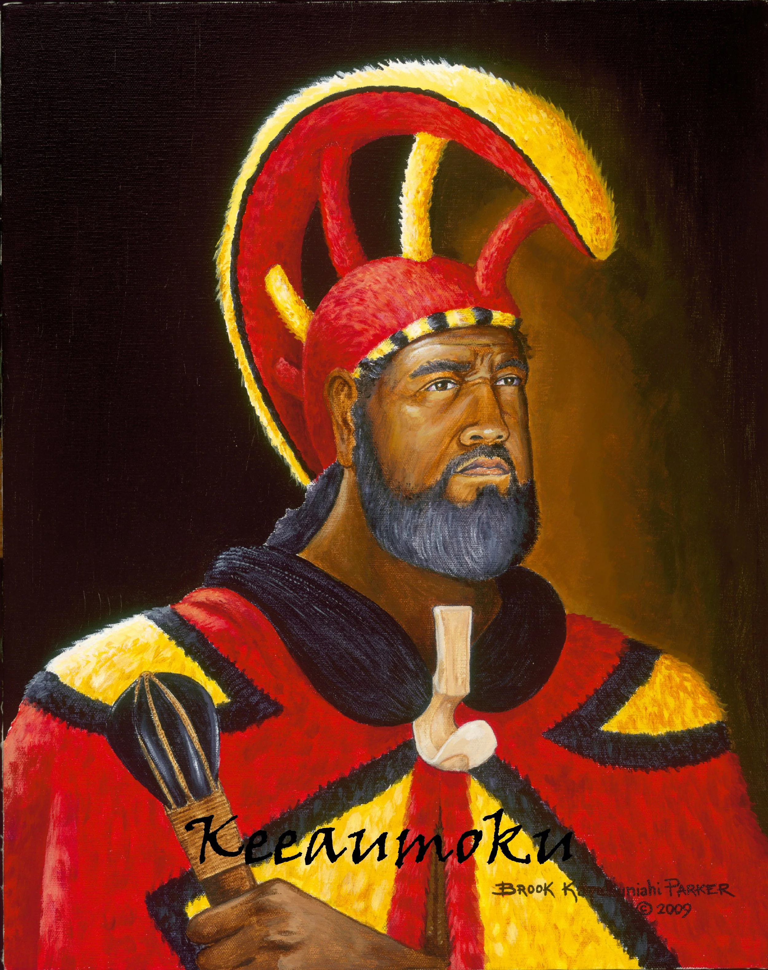
Named after Chief Keeaumoku Papaʻiaheahe, the father of Queen Kaʻahumanu and a trusted advisor and military leader under Kamehameha I. Keeaumoku played a crucial role in helping Kamehameha unite the Hawaiian Islands in the late 1700s. His family line continued to shape the kingdom — his daughter Kaʻahumanu became Kamehameha’s favorite wife and later served as Kuhina Nui (a powerful co-ruler).
(Sources: Pukui, Elbert & Mookini, Place Names of Hawaiʻi, University of Hawaiʻi Press, 1974; Hawaiʻi State Archives – Aliʻi Biographical Files.)
Wilder Avenue

Wilder Avenue is named after Samuel Gardner Wilder (1831–1888), a businessman and government official during the Hawaiian Kingdom. Wilder served as Minister of the Interior under King Kalakaua, and he founded the Wilder Steamship Company, which connected Hawaiʻi’s islands through inter-island transport. His influence on infrastructure and trade helped modernize Honolulu during the 19th century.
(Sources: Hawaiian Kingdom Government Archives, Cabinet Records of King Kalakaua; The Pacific Commercial Advertiser, August 1888.)
Pensacola street
Pensacola Street is named after the USS Pensacola, a U.S. Navy steam sloop that first arrived in Honolulu in the 1860s. The ship became well known in the islands for its visits during the reign of King Kalakaua. Historical accounts record that the Pensacola brought King Kalakaua home from San Francisco following his world tour in 1874.

The Pensacola was one of the Navy’s earliest steam-powered warships, used during the American Civil War and later assigned to the Pacific Squadron. Its presence in Honolulu Harbor symbolized the growing diplomatic and trade ties between the Hawaiian Kingdom and the United States during the late 19th century.
Sources: U.S. Department of State, Office of the Historian. “King Kalakaua’s World Tour,” in Foreign Relations of the United States, 1894, Appendix II: Affairs in Hawaii,” Document 2a – Correspondence between the U.S. Legation and Department of State.” https://history.state.gov/historicaldocuments/frus1894app2/d2a
PIIKOI STREET

Jonah Pi’ikoi (1804–1859) was a high chief from Kauaʻi, born into a line of ali’i connected to the royal families of Hawaiʻi. His name, Pi’ikoi, means “to ascend.”
His son, David Kahalepouli Pi’ikoi, was the father of Prince Jonah Kuhio Kalaniana’ole and Prince David Kawananakoa — both important figures in Hawai’i’s history. Kuhio is remembered as “The People’s Prince” and is honored each year on Prince Kuhio Day, while Kawananakoa helped shape the modern ali’i lineage that continues today.
Today, Pi’ikoi Street is one of Honolulu’s main roadways, connecting Ala Moana Boulevard to the H-1 Freeway — a lasting reminder of the Pi’ikoi family’s legacy in Hawai’i.
Sources:
Pukui, Elbert & Mookini. Place Names of Hawaiʻi. University of Hawaiʻi Press, 1974.
Department of Hawaiian Home Lands. Prince Kūhiō Day Brochure. March 2021.
https://dhhl.hawaii.gov/wp-content/uploads/2021/03/8.5x11-DHHL-Prince-Kuhio-Day-Brochure.pdf